Besides pansharpening, the GRIP team has also faced other important data fusion problems, such as the multi-resolution fusion of Sentinel-2 images, the reconstruction of vegetation features from SAR-optical mixed time series, the optical-guided despeckling of SAR images, to mention some representative examples.
Images provided by the ESA Sentinel-2 mission are rapidly becoming the main source of information for the entire remote sensing community. Due to a sensor design trade-off, images are acquired (and delivered) at different spatial resolutions (10, 20 and 60 m) according to specific sets of wavelengths. The proposed FUSE CNN combines 10m and 20m bands to super-resolve the 20m ones.
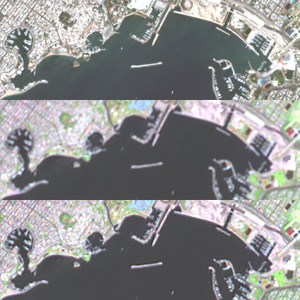
SAR images are affected by an inherent “noise” known as speckle. We propose a new method for SAR image despeckling, which leverages information drawn from coregistered optical imagery. Filtering is performed by patchwise nonlocal means, working exclusively on SAR data. However, the filtering weights are computed by taking into account also the optical guide, which is much cleaner than the SAR image, and hence more discriminative.

Sensitivity to weather conditions, and specially to clouds, is a severe limiting factor to the use of optical remote sensing for Earth monitoring applications. A possible alternative is to benefit from weather-insensitive synthetic aperture radar (SAR) images. In this work we propose a CNN model for cross-temporal and cross-sensor (SAR-optical) reconstruction of the normalized difference vegetation index (NDVI), a widespread used optical vegetation index.