Image segmentation is an extremely wide topic of Computer Vision. Its definition is not univocal and is therefore commonly expressed in general terms such as “a process aimed to partition an image in regions which are homogeneous with respect to given visual properties”. Applicability to a large variety of domains, like remote sensing, security, automation, and medical imaging, to mention a few, has contributed to enlarge the set of different solutions available in literature.
The GRIP team has experienced the design of image segmentation algorithms for remote sensing applications since ‘99. In this page you can found demos, codes, and references of some representative GRIP projects on image segmentations.
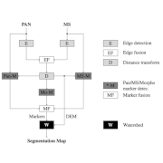
To deal with high-definition multiresolution satellite images such as Ikonos, GeoEye, WorldView, a multiresolution watershed-based segmentation technique is proposed. To guarantee the preservation of details at fine scales while keeping spectral consistency, the panchromatic and multispectral components are processed independently, extracting both edge maps and morphological and spectral markers to be fused in a full-resolution segmentation framework.

The Texture Fragmentation and Reconstruction (TFR) algorithm, addresses the unsupervised segmentation problem based on a hierarchical multiple Markov chain model. The fragmentation step allows one to find the elementary textures of the model, while the reconstruction step defines the hierarchical image segmentation based on a probabilistic measure (texture score) which takes into account both region scale and inter-region interactions.
A split-and-merge algorithm for the segmentation of multiresolution remote-sensing images is proposed. The splitting phase singles out clusters of connected regions that share the same spatial and spectral characteristics. These clusters are then regarded as atomic elements of more complex structures, particularly textures, that are gradually retrieved during the merging phase.
Most remote sensing images exhibit a clear hierarchical structure which can be taken into account by defining a suitable model for the unknown segmentation map. To this end, one can resort to the tree-structured Markov random field (MRF) model, which describes a K-ary field by means of a sequence of binary MRFs, each one corresponding to a node in the tree. Here we propose to use the tree-structured MRF model for supervised segmentation.
A Tree-structured Markov Random Field (TS-MRF) model-based algorithm is proposed for unsupervised segmentation of multispectral remote sensing images. The image is recursively segmented in smaller and smaller regions until a stopping condition, local to each region, is met. Each elementary binary segmentation is obtained as the solution of a MAP estimation problem. To improve segmentation, a split-and-merge strategy has been devised.